Switzerland is world-famous for its mesmerizing nature and hiking is undoubtedly the best way to discover the country’s countless natural landmarks and attractions. The authorities know it, which is why Switzerland’s best and most popular hiking trails are all well-marked, easily accessible, and maintained to the highest standards.
Regardless of which Swiss region you’re currently in, you’ll be able to find at least one epic hiking trail close. Although multi-day hikes are generally more rewarding, the numerous shorter trails can boast equally gorgeous views and are better suited for less-experienced hikers and those who just don’t have enough time for a long-distance hike.
Mountain trails, forest hikes, epic waterfall views, and loop trails around lakes are relatively common in the Alpine country, so here are all the best trails that can be explored on day hikes in Switzerland!
Creux de Van Hike

Creux du Van is a natural rock-climbing arena in the Jura Mountains, situated in the far west of the country. The area attracts many avid rock climbers, thanks to hundreds of via ferratas and other rock climbing opportunities in the region. But some of the country’s best hiking trails are also in the region, so there are plenty of reasons to explore the area even if you have no interest in rock climbing.
One of the best hiking trails in Creux du Van is along the top of the rock arena. It’s a short but sweet hike; the trail is approximately 14 kilometers with an elevation change of 780 meters, and it takes 4-5 hours to complete this day hike. It’s an easy trail, meaning that it’s suitable even for those with very little previous hiking experience.
To reach the trailhead you will first need to get to Noiraigue railway station, which is easily accessible from Neuchatel. Then head some 100 meters east until you’re on Ferme Robert Road, and the trailhead will be to your right, at the entrance into the forest. There’s also a free parking lot at Ferme Robert Road, so you can drive practically to the trailhead if you want.
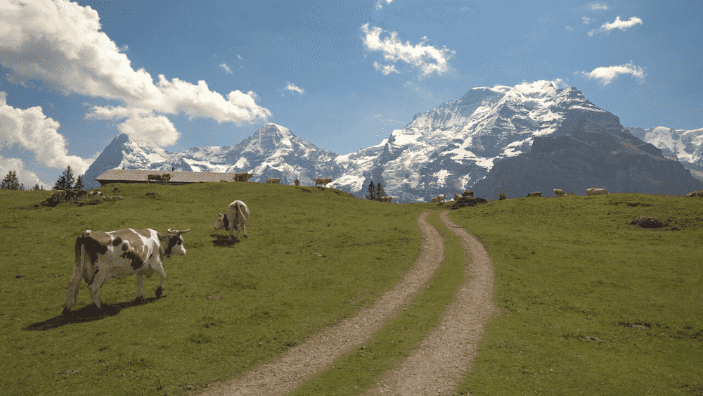
The Eiger Trail

The Bernese Alps are home to some of Switzerland’s tallest summits, and the good news is that you don’t have to be a very experienced Alpinist to experience the views offered at such high altitudes. The Eiger trail is one of the easier hikes in the Bernese Alps, and it’s suitable for most hikers with some experience and good equipment.
The hike begins at the Eiger Glacier Station, which is accessible by a 15-minute cable car ride from Grindelwald. If you choose to walk the trail in this direction, you will mostly be going downhill, which makes the trail much easier to handle and allows you to move faster. The total length of the trail (from the Eiger Glacier Station to the Alpiglen inclined railway station) is just over 7 kilometers.
It should take you 2-3 hours to complete the hike on the north face of the Eiger, but the total time depends on the hiking direction. Also, this time doesn’t include any stops you might make along the way to take in the fabulous views, which is certainly the highlight of the entire trail. Bring a pair of binoculars and you might even spot some rock climbers in the distance!
Mount Rigi Panorama Trail
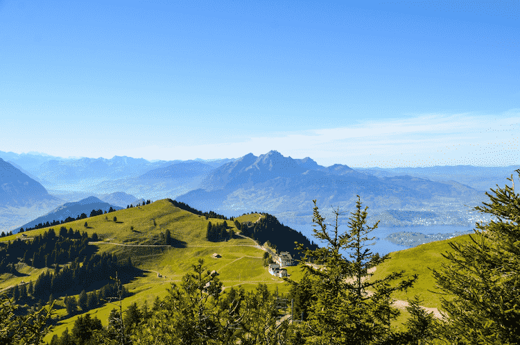
If you are staying near Zurich or Lucerne, the Mount Rigi Panorama Trail is one of the best hikes you can do in the region. First, you need to get to Goldau, which can be done in about half an hour from Lucerne or some 45 minutes from Zurich. There are direct trains to Goldau from both Swiss cities.
An inclined railway connects Goldau to Rigi Kulm, and the ride to the summit is around 45 minutes. The trailhead is right at the Rigi Kulm station, so you can begin hiking the moment you get off the train. Another option is to drive to the Kräbel cable car station; there’s a parking lot right next to the station and the cable car will get you to Rigi Scheidegg at the opposite end of the trail.
If you’re starting the hike at Rigi Kulm, the trail is approximately 8 kilometers long and it’s mostly downhill. It takes just under 3 hours to complete the hike in this direction, but it will take a little longer if you start at Rigi Scheidegg because of the uphill sections.
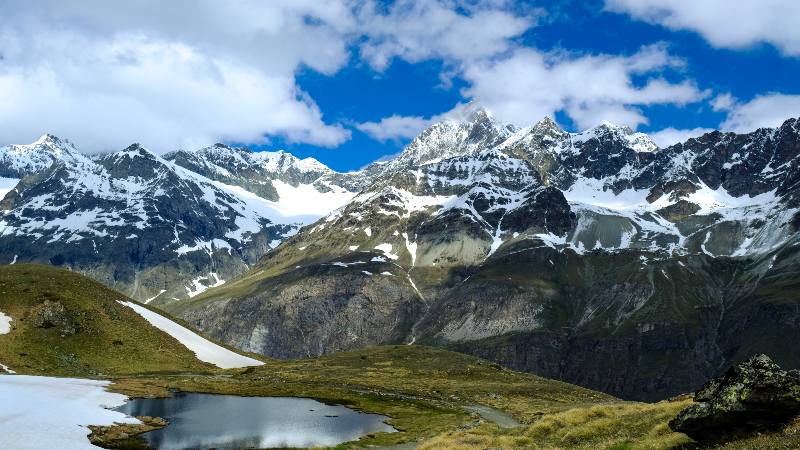
Aletsch Glacier Panorama Trail

The Aletsch Glacier Trail is a more challenging hike, so perfectly suited for experienced hikers. The trail is of medium-difficulty and good physical fitness is necessary due to technical requirements and steep incline of the path.
It’s a point-to-point hike from the (upper) Moosfluh cable car station to the (upper) Fiescheralp cable car station. The trail is 12 kilometers long with a total ascent of 510 meters and a descent of 630 meters. It’s possible to complete the hike in under four hours, but the total time necessary depends on trail conditions and how often you stop for breaks.
The views along the way are phenomenal. You can see the stunning Aletsch Glacier and the towering peaks that surround it. About halfway through the hike, you’ll reach the Gletscherstube hut, which is the best place for a break and maybe even a meal. They have the most delicious apple tart and quite a few other excellent Swiss specialties.
Hardergrat Trail
The Hardergrat Trail is perfect for all travelers staying in Interlaken. The trailhead is easily accessible on foot from the town, it’s a generally easy hike, and it offers some gorgeous panoramic views of Lakes Thun and Brienz. Although there are easier versions of this hike, I want to tell you all about the entire 24-kilometer trail that’s lauded as one of Switzerland’s best mountain ridge hikes.
It takes around 6-8 hours to complete this hike, depending on your pace and how often you’re stopping for breaks. It’s generally a challenging hiking trail and suitable only for experienced hikers, but you don’t really need any technical equipment except for a good pair of hiking shoes.
The trail starts in Interlaken; go to the bottom station of the Harderbah and take the cable car to Harder Kulm. From there, you’re walking all the way to Brienzer Rothorn and expect to climb around 3000 meters in total.
The views along the way are absolutely magical, and you can experience a beautiful panoramic vista of Lake Brienz throughout the entire hike. At Brienzer Rothorn you can ride the cable car into Brienz, where you can spend as much time as you wish, or just get on the train back to Interlaken (15-20 minutes).
Five Lakes Hike
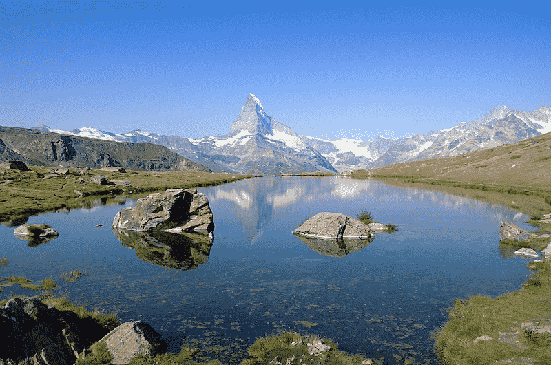
The Five Lakes Trail is one of the best summer hikes near Zermatt. The entire trail is signposted so it’s very easy to follow. The terrain is generally easy without too much of an incline, so the hike is perfectly suitable for families with kids as young as six. Blauherd is the starting point of this hiking trail, and it can be easily accessed by cable cars from Zermatt.
Want To Save This For Later?
Before you even start walking the trail, you can experience some fabulous views of the iconic Matterhorn. Feast your eyes on this majestic mountain, and then start heading in the direction of Stellisee, where you can get some stunning photos of the reflection of the pyramid-shaped peak in the lake.
The five lakes you will discover on this hike are Stellisee, Grindjisee, Grünsee, Moosjisee, and Leisee. The final lake (Leisee) is very close to the Sunnegga cable car station, which can get you back to Blauherd and then into Zermatt. In total, it takes 2-3 hours to walk the 10 kilometers of this (almost) loop trail, and it’s worth noting that two of the lakes are swimmer-friendly.
Oeschinensee Hike
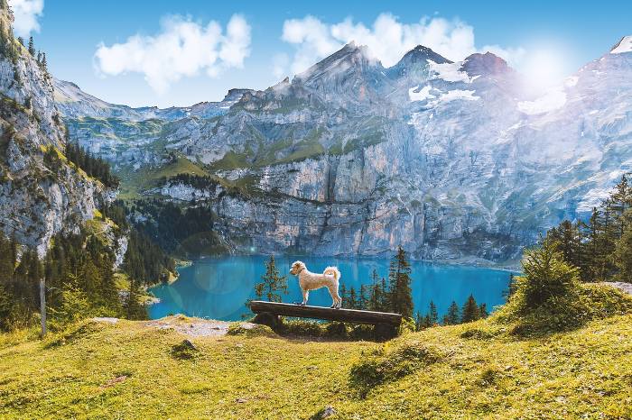
Lake Oeschinen is situated in Kandersteg, about 45 kilometers outside Interlaken and 65 kilometers from Bern. The drive to the lake is shorter from Interlaken, but if you’re traveling by train in Switzerland, it’s quicker to get to the lake from Bern.
The easiest trail near the lake is a loop hike around the lake shore, and this is suitable for everyone. But that’s not the best way to enjoy the gorgeous panorama of the lake, so if you want to make the most of this hiking trip, get ready to explore an epic 8-kilometer trail.
The trailhead is near Zur Sennhütte restaurant, where you can stock up on food and drinks for the hike. The first half of the hike is somewhat steep, but it’s nothing too challenging. When you complete the first part of the ascent you will reach the balcony trail with gorgeous views of the Alpine lake and the surrounding landscapes.
Then it’s only about 2 kilometers to the Oberbärgli restaurant, where you can start to descend toward the lake shore. The trail follows the northern shore of Lake Oeschinen, and will eventually take you back to Zur Sennhütte. It’s worth noting that the hike can be done in either direction, and it’s generally a bit easier if it’s done counterclockwise.
Lauterbrunnen Valley Hike
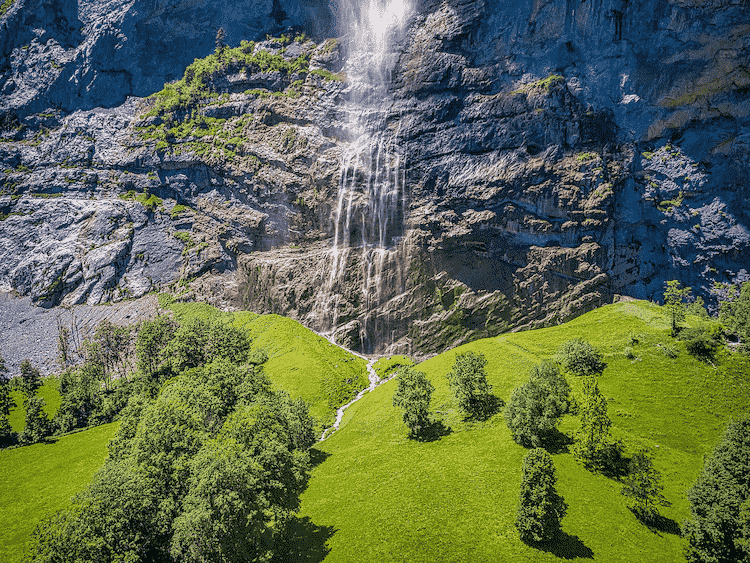
The Lauterbrunnen Valley is famous for its Alpine meadows, gorgeous waterfalls, and views of the Swiss Alps. It’s home to some of the best hikes in Switzerland, so choosing the best trail in this region is the most difficult thing about hiking in Lauterbrunnen.
The most special thing about Lauterbrunnen Valley is that it’s home to 72 waterfalls, so the ideal hike through the area would allow you to spot most of them. Start at the Lauterbrunnen train station and walk through the entire valley, all the way to Stechelberg. There you can take a bus back to Lauterbrunnen, stop at the iconic Trummelbachfalle, or even ride the cable car to Schilthorn for a day full of epic views.
The path from the train station in Lauterbrunnen is generally very easy. It’s just under 7 kilometers and can be walked in two and a half hours, even if you take the time to stop and take photos every now and then. The most famous of the Lauterbrunnen waterfalls can be seen at the beginning of the hike; it’s the Staubbach Waterfall that runs down the cliffs behind the village houses.
Hörnlihütte Hike
Hörnli Hut is a mountain hut that serves as a base camp for ascents on the Matterhorn. If you’re not brave enough to attempt to climb the pyramid-shaped peak, why not hike to the base camp? You can still experience spectacular panoramic views of the Matterhorn, but you won’t have to risk your life climbing the mountain face.
The trail is not very long but it is rather steep, so I would recommend it only to more experienced hikers. It’s a must if you’re staying in Zermatt especially since it only takes about 4 hours to complete the out-and-back hike. Schwarzsee is the starting point of the trail, and it can be reached by gondolas and cable cars from Zermatt.
The Alpine lake is also the lowest point of the hike and you’ve got a lot of climbing to do until you reach Hörnli Hut. The total elevation gain is 725 meters, which is a lot considering you will do most of the climbing in the first two hours or so of the hike.
Schynige Platte Panorama Trail
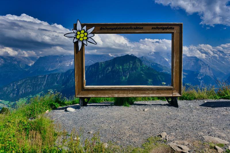
The Schynige Platte Panorama Trail is another must if you’re staying in Interlaken or its surroundings. The trail is easily accessible from this Swiss city, and it boasts some spectacular scenic views. It’s a moderately difficult hike, so perfect for hikers who want a bit of a challenge, but don’t want to be exhausted by the end of the day.
This is a loop hike of 5.6 kilometers, with a very small elevation gain of just 150 meters. The most challenging part of the hike is that you’re walking on a mountain ridge most of the time, which can be unnerving for hikers with a fear of heights. The trail can be done in about 2 hours, or some 3 hours if you’re going at a slower pace or hiking with children, which is perfectly possible.
The Schynigge Platte inclined railway station is both the starting and the final point of the hike. You’ll first head northwest to Gumihorn and Daube, and then east until you reach the foot of Loucerhorn. Then it’s time to head west again until you’re back at the railway station.
Schäfler Ridge Hike

The Schäfler Ridge Hike is one of the best and most popular trails in the Appenzell region. The hike starts in Wasserauen, where you can take a cable car to Ebenalp and shorten the total trail by more than 5 kilometers.
The trail is 9.5 kilometers long if you ride the cable car to Ebenalb, where our journey begins. The total elevation change is just 350 meters; it sure doesn’t sound like a lot, but you’ll cover that ascent in only 2 kilometers, so the experience is quite intense. And that is primarily why I suggest you take that cable car, instead of climbing all the way from Wasserauen to Ebenalp.
Berggasthaus Ebenalp is the first stop on this trail, very close to the upper railway station. Stock up on drinks and snacks for the hike, and start heading towards Schäfler. The ridge trail is rocky and narrow with some technical descents, but it’s nothing outrageous and can be completed by any experienced hiker who isn’t messing around.
The most difficult part of the hike is the descent to Seealpsee, mostly because the path is often wet and slippery. From the lake, it’s only about 40 minutes back to Wasserauen.
Zermatt to Gornergrat Hike

I promise this is the last hiking trail near Zermatt that I’m going to mention. It’s also the most difficult hike in the Zermatt region, so a great option for avid hikers who want to break a sweat while exploring Switzerland’s magical landscapes.
There are multiple ways you can shorten the hike (gondolas and trains), plus you have the option of going to Gornergrat and then descending into Zermatt. But the best and most difficult way is to hike from Zermatt to Gornergrat; it’s an 11-kilometer point-to-point hike, with an elevation gain of 1,500 meters. It takes about 5 hours to reach the rocky ridge, and it’s another 4 hours if you want to hike back to Zermatt.
It’s worth noting that there’s a mountain hotel at Gornergrat where you can spend the night, plus you will pass by many restaurants and mountain huts while hiking the trail. The upper station of the Gornergrat railway is the final point of the hike, and the train can take you back to Zermatt in just 50 minutes.