
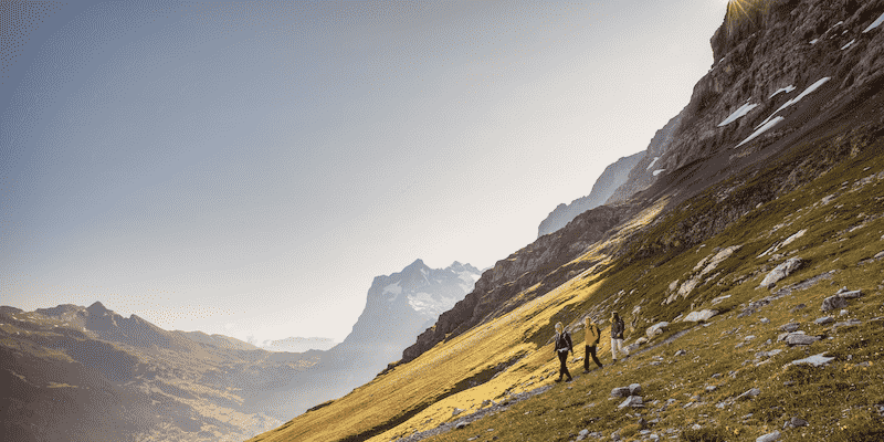
Interlaken is a lovely little town nestled between two lakes with a river running through it. Known as the gateway to the Bernese Oberland region of the Swiss Alps and its famous peaks – Eiger, Mönch, and Jungfrau, it is a paradise for hikers.
This beautiful town sits at 566 meters (1,857 feet) above sea level with a small population of just 25,000 people so it is not big and busy in any way. Plus, being surrounded by the Bernese Alps and sitting between Lake Thun and Lake Brienz makes it about as picturesque as it gets.
Interlaken, while being great for hiking, also attracts many mountain adventurers. Everything from whitewater rafting to paragliding, and canyoning is also available here.
It is also the perfect place for hikers looking to explore the Jungfrau region to base themselves with easy public transport links to the best hiking trails in the region that will take you into the alpine landscapes of the surrounding mountains.
Join me as I run through some of the top hikes Interlaken has to offer from gentle walks to challenging summit hikes so you can explore all the top trails the Jungfrau Region has to offer.
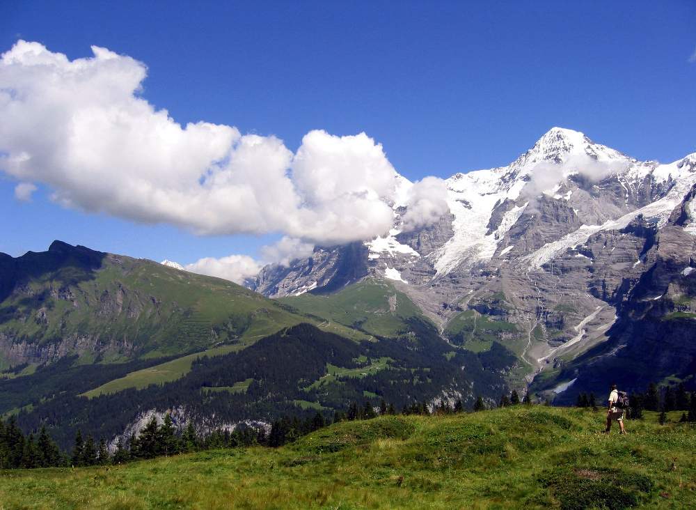
The Rugen Trail

The Rugen Trail is an easy hike that can be done as a family and it has some awesome things to see along the way – plus being a loop hike, you get to start and finish at the same place which makes transport a little easier.
The hike starts and ends at the Rugenbahn mountain station which you can reach by taking the funicular from Wilderswil to the Rugenbahn station.
From there, simply follow the well-marked trail as it takes you through lovely forests and alpine meadows. Along the way, you’ll cross a wooden bridge, little mountain streams, and get to see some great views.
The highlight of the hike is the Rugen viewpoint where you can stare across Lake Thun, Lake Brienz, and even see the famous trio of Eiger, Mönch, and Jungfrau peaks.
Once you complete the loop, you can either hike all the way back down or take the funicular.
- Hike Type: Loop
- Distance: 6 kilometers
- Time: 2-3 hours
- Difficulty: Easy
The Eiger Trail
The Eiger Trail hike is probably the most famous and popular hiking trail around Interlaken. The reason is that it takes you along the base of the legendary Eiger North Face, a world-famous and dramatic wall that is revered in the rock climbing world for its deadly routes.
The hike begins at Eigergletscher station (Eiger Glacier train station) and ends at Alpiglen. To get to the start you will have to take the Jungfrau Railway from Kleine Scheidegg to Eigergletscher.
The trail is well-marked as it finds its way through alpine meadows, rocky terrain, and dramatic cliffs. The highlight is the up-close views of the legendary Eiger, as well as the surrounding mountains and glaciers.
The hike is not that tough at 6.4 km and should take around 3 hours, there are some parts with some uneven terrain though.
Once you reach the end at Alpiglen, you can catch a train back to Kleine Scheidegg or continue exploring the region via the many other Interlaken hiking trails that connect at the Eiger Glacier station.
This is one of the best hikes in the Jungfrau region simply for the views of Eiger as you can get up close and personal with the scale of its North Face.
- Hike Type: Point-to-point
- Distance: 6.4 kilometers
- Time: 2-3 hours
- Difficulty: Moderate
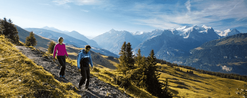
Schynige Platte Ridge Trail

If you are looking for a slightly more challenging hike with an epic view then the Schynige Platte Ridge Trail might be the one for you.
It is not overly challenging but you will want some good hiking shoes to keep your wits about – most experienced hikers can manage this one.
The hike starts at Schynige Platte and ends at First. To reach the starting point you you have to take the old cogwheel train from Wilderswil to Schynige Platte.
What makes this hike special are the panoramic views of the Jungfrau, Mönch, and Eiger peaks, which are present for most of the hike.
The trail will also take you through alpine meadows (full of colorful wildflowers during the summer months) and to several viewpoints where you can pause and take it all in.
INTERLAKEN REGION UNCOVERED: A FIRST-TIMER'S GUIDE (UPDATED FOR 2026)
Everything you need to know when planning a trip to the Interlaken, Grindelwald & Lauterbrunnen area.
AFFORDABLE AT ONLY $35

At the trail’s end, you can walk down to Grindelwald or take the down cable car from First. Alternatively, you can break the hike into two as I did over 20 years ago when I first came to Switzerland. You can stay at the Faulhorn hut and then hike down to Grindelwald the next morning. It’s a great way to make a two-day hike out of it and experience Swiss mountain huts simultaneously.
- Hike Type: Point-to-point
- Distance: 7.6 kilometers
- Time: 3-4 hours
- Difficulty: Moderate
Lauterbrunnen To Stechelberg
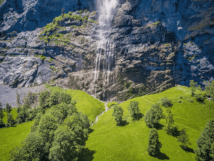
The Lauterbrunnen to Stechelberg hike is a delightful trail that takes you through the Lauterbrunnen Valley, also known as the Valley of 72 Waterfalls.
The hike beings in the little village of Lauterbrunnen, which can be reached by train or bus from Interlaken.
From the village, simply follow the well-marked path along the Lütschine River. You will stroll past so many waterfalls as well as through meadows, past little Swiss chalets, and more cascading waterfalls.
You will also see great views of the surrounding mountains, and be sure to pause at the huge Staubbach Falls as they are a sight to see.
You will end the hike in the little village of Stechelberg, which is well worth exploring. After that, you can catch a bus back to Lauterbrunnen.
The hike is pretty easy and ideal for families or if you want a chilled hike with stunning scenery.
- Hike Type: Point-to-point
- Distance: 4.6 kilometers
- Time: 1-2 hours
- Difficulty: Easy
[lauterbrunnen-itinerary]
Niederhorn Ridge Trail

The Niederhorn Ridge Trail is a loop trail that takes you to the summit of Niederhorn while giving you awesome views of Lake Thun and the Bernese Alps along the way.
The hike starts and ends at the Niederhornbahn mountain station. To reach the starting point, take a bus from Interlaken to Beatenbucht, then catch a ferry to Beatenberg. From there, a cable car will take you to the Niederhornbahn station.
The trail starts at the Niederhorn summit and follows the ridge (hence the name). The views along the way are spectacular as you traverse through alpine meadows, forests, and past rugged cliffs.
The trail follows a well-maintained path which makes life a lot easier. Once you complete the loop, take the cable car back down or hike.
The Niederhorn Ridge Trail is quite challenging and it is not for every level of hiker as you will experience some steep drop-offs along the way.
It is however an unforgettable experience so if you are confident and fit, you should certainly give this hiking trail a go.
- Hike Type: Loop
- Distance: 10 kilometers
- Time: 4-5 hours
- Difficulty: Moderate
Harder Kulm

The Harder Kulm hike is a rewarding hike that takes you to the summit of Harder Kulm which has amazing views of Interlaken and the surrounding mountains.
The hike begins at Interlaken Ost train station where you can catch a funicular to Harder Kulm. Once you arrive, be sure to enjoy the summit before following the well-marked trail that brings you back down to Interlaken.
You will hike through lovely little alpine villages along the way have the turquoise waters of Lake Brienz as your backdrop.
You can also do the hike in reverse, hiking up to the viewpoint of Harder Kulm, also known as the Top of Interlaken. The trail starts near Interlaken’s city center and goes pretty much uphill from there.
- Hike Type: Out and Back Route
- Distance: 7 kilometers
- Time: 2-3 hours
- Difficulty: Moderate
Mount Niesen Panorama Trail
The Mount Niesen Panorama Trail is a pretty awesome hike that takes you to the summit of Mount Niesen, known as the “Swiss Pyramid”.
The hike starts and ends at the Mülenen funicular station. To reach Mülenen, take a train from Interlaken to Spiez, then transfer to a regional train to Mülenen.
Once you arrive at the funicular station, you will slowly hike up to the summit through forests and meadows with panoramic views of Lake Thun and the surrounding mountains in the background.
Once you reach the summit, you’ll be able to see a 360-degree panorama that stretches from the Jura Mountains to the Bernese Alps on a clear day. The trail then goes back down, again through forests and meadows back to the funicular station.
The Mount Niesen Panorama Trail is quite challenging but it can be done by most and it is certainly worth it for the views of the Jungfrau Region.
- Hike Type: Loop
- Distance: 11 kilometers
- Time: 4-5 hours
- Difficulty: Moderate
Giessbach Waterfall Hike

The Giessbach Waterfall Hike is an easy loop trail with a lot to offer – mainly the views of the Giessbach Waterfall and Lake Brienz you will get to see along the way.
The hike beings and ends at the Giessbachbahn funicular station. To reach the starting point, take a bus or boat to Giessbach Schiffstation, where you can catch the funicular to the top.
You will hike through lovely forests and have the chance to stop at several viewpoints overlooking the stunning Giessbach Falls. This waterfall is particularly powerful as it plunges off a cliff into Lake Brienz.
The Giessbach Waterfall Hike is an easy and family-friendly hike that can be done by all which means everyone can see these stunning scenes of the Jungfrau Region.
- Hike Type: Loop
- Distance: 6.8 kilometers
- Time: 2-3 hours
- Difficulty: Easy
Augstmatthorn Ridge Hike

The Augstmatthorn Ridge Hike is a stunning loop trail that takes you to the summit of Augstmatthorn with great views along the way – like all the hikes in the article. A great tip for this one is to pack a picnic so you can have it at the summit.
The hike starts and ends in Habkern, a village near Interlaken. To reach Habkern, take a bus from Interlaken to Habkern Post.
From Habkern Post you can simply follow the well-marked trail that climbs up to the summit. Along the way, you’ll be able to see lovely views of Lake Thun, Lake Brienz, and the Bernese Alps too.
When you reach the summit be sure to stop for that picnic as it is the perfect spot and a great chance to have a rest before hiking back down to Habkern to complete the loop.
- Hike Type: Loop
- Distance: 10 kilometers
- Time: 4-5 hours
- Difficulty: Moderate
Want To Save This For Later?
Hasliberg Hike
The Hasliberg Hike is a point-to-point trail that takes you from Mägisalp to Meiringen, and what makes it special are the views of the Hasli Valley along the way.
To reach the starting point at Mägisalp, take a bus from Meiringen to Bidmi and then ride the gondola to Mägisalp.
At Mägisalp, follow the well-marked path along the ridge which leads you through charming Swiss villages, meadows, and forests.
Along the way, you’ll see views of the famous Wetterhorn, the Eiger, and surrounding mountains too. This hike will also have you walking past traditional Swiss farms and lovely alpine architecture.
The hike ends in Meiringen where you can catch a train or bus back to Interlaken.
- Hike Type: Point-to-point
- Distance: 8.5 kilometers
- Time: 3-4 hours
- Difficulty: Moderate
Aare Gorge Canyon Walk

The Aare Gorge Canyon Walk is a pretty unique hike as it takes you through a narrow gorge carved out by the Aare River.
The hike starts off at the Aareschlucht Ost entrance and ends at Aareschlucht West. To reach the starting point, take a train from Interlaken to Meiringen, then a bus to Aareschlucht Ost.
The trail follows a wooden walkway that winds its way through the gorge – how cool is that. You will have awesome views of the Aare River as it rushes its way through the towering cliffs that form the Aare Gorge.
Between the crystal-clear turquoise waters, the power of the Aare River, and the stunning cliffs, it is a hike that is hard to beat – plus it is easy so anyone can do it.
At the end of the trail, you can either walk back through the gorge or take a shuttle bus to the starting point.
- Hike Type: Out-and-back
- Distance: 3.5 kilometers
- Time: 1-2 hours
- Difficulty: Easy
Murren To Grutschalp
The hike from Mürren to Grutschalp takes you to the delightful car-free village of Mürren which is perched high above the Lauterbrunnen Valley. The views of the valley and mountains from Mürren are pretty incredible.
To reach Mürren you will need to take a cable car from Lauterbrunnen or Stechelberg. From there, simply follow the well-marked trail that goes down to Grutschalp.
Along the way, you’ll wander past charming alpine chalets, meadows filled with wildflowers, and get to enjoy some awesome views of the Eiger, Mönch, and Jungfrau peaks.
Once you reach Grutschalp, you can take a cable car or train back to Lauterbrunnen.
- Hike Type: Point-to-point
- Distance: 7.6 kilometers
- Time: 2-3 hours
- Difficulty: Easy


My wife and I would like to hike Switzerland for 3-4 days at the end of August. We are pretty fit and could handle 10-20 kilometers per day. We will be traveling from Paris on the 24th or 25th and staying in Interlaken or Zermatt or ? or a combination. On the 29th we need to get on a plane to London. Any recommendations for places to stay and must do hikes. We have about a $200 per day budget for lodging. Where would be the best place to fly out of to get back to London?
Hi Donald
Sounds like a fun trip. I offer customers 1-1 consults on video calls for such long discussions if you are interested https://switzerlanding.com/custom-travel-itinerary-planning/
Otherwise, the best bet is to use the search function on the website as I have dozens of posts that address these questions in various ways
cheers
ashley